Today I finally got in another long hike! It seems every
time I've wanted to go hiking lately, another storm has come up! There have
been a few showers since the last big storm, but nothing to really make the
trails difficult.
This time I drove out to the Beaver Basin trailhead and
hiked toward the shore from there. The first part of the hike was actually part
of a short interpretive trail that leaves from the campground there, but I kept
going past that loop. It was interesting how different this was from the
Mosquito loop trail I hiked back in July. There was a bit more up-and-down to
the terrain here, and there were giant chunks of rock sticking out of the
ground and eroding out of hillsides. The sandstone layers were very
distinctive. I kept spotting trees that had grown in the strangest of positions
– hanging over the edge of the rock, propped up on their roots…
There was jewelweed growing in this marshy area. It was mostly done blooming, but I managed to get a couple of videos showing how the pods burst open! This is why they're called "touch-me-not"!
Note the twenty-foot root growing along the rock ledge from the tree at the far right...
As I got closer to the shore I went from woods, through various wetlands, and then out onto sand. The trees here were different, there wasn't much growing on the ground, and the path was loose, white sand. Gradually I started hearing the distant noise of waves crashing. I was almost there!
This is a view of Little Beaver Lake. There was a trail continuing from here.
Squirrel! First he was busy stuffing his face with pine seeds...
Then he saw me, jumped up on a stump and started scolding me! How dare I hike in his forest?!
A few parts of the trail had canvas mesh in the sand to keep the hill from eroding.
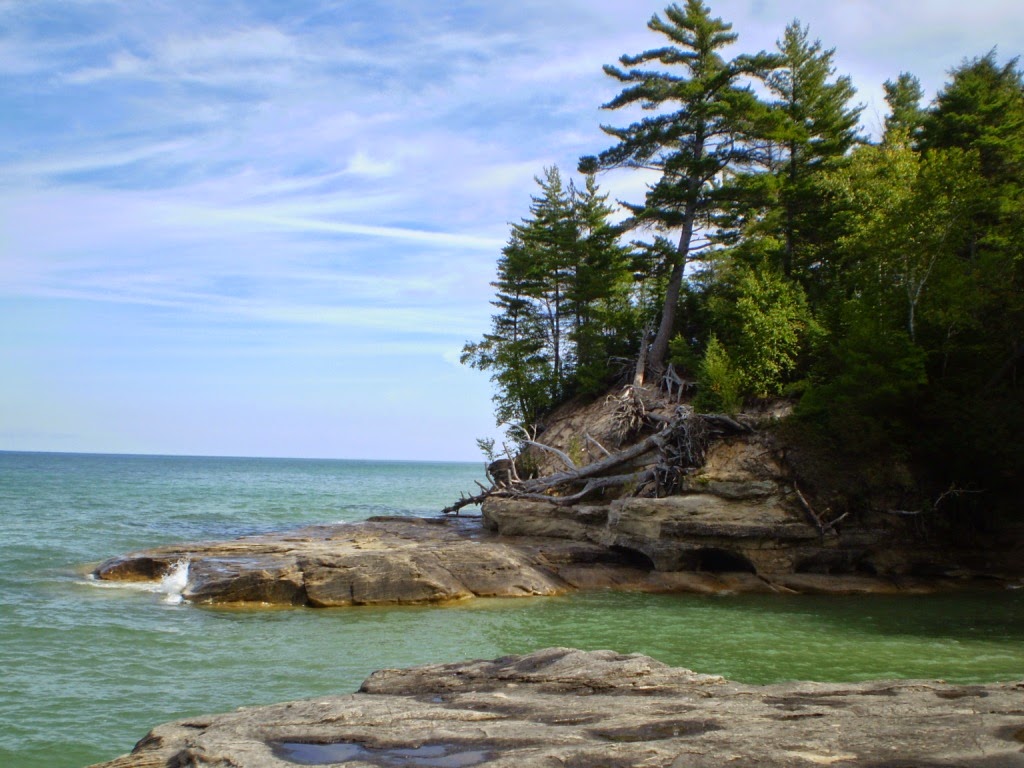
The coves are where the rock is first exposed as you travel
west along Twelvemile Beach. A series of small individual alcoves carved into
the rock along the shores, where the cliffs are just beginning. Marc had
described this area to me at one point (he does a LOT of hiking, kayaking,
etc.) but I was not quite sure what to expect, or if I would be able to get
down inside one of the coves, to the water’s edge.
The first cove was pretty small, and steep – not much there.
The second one was a lot like what I had pictured, but again, small and steep.
The next was bigger – but what looked like a path down turned out to be a short drop-off, and I could tell I would not be able to get back out that way! However, as I was getting my first look inside, I had seen someone climbing out the other side, and that route looked a lot more doable.
It wasn't very far across the cove, but the trail to get
there was longer – and hard! It went straight up, over, and down around the
huge overhanging rock outcrop that formed the back wall of the cove. There were
stairs, but they were so steep it would have worked better as a ladder! It was
harder because the steps were very far apart, almost two feet sometimes. I had
a hard time getting up, and I’m tall! This short section was the toughest part
of the entire hike.
But I was rewarded for my struggles! Once I made it back
down from the top, it only took a few minutes to spot the path leading down
into the alcove. And it was definitely one I would be able to climb back out
of!
I took a few pictures but decided to eat my lunch before
really getting down to business. I sat down on a handy sandstone ledge, and in
a minute I was COLD! I had been starting to get a little warm, hiking in my
sweatshirt, but this rock had absorbed all of the night’s chill and then been
in the shade all day, and that cold was being transferred directly to my legs
and rear end! I took my windbreaker out of my pack and put that in between. It
was better than nothing but the chill soon seeped through.
All those years in Girl Scouts, and here I was without a
sit-upon!
After I ate I spent some time walking around and getting
photos and videos of the cove from various angles, watching how the narrow
mouth of the cove affected the way the waves moved and how the rock was
eroding. Then I took one last look down the coast and climbed back up to the
trail, pausing only to watch a chipmunk who was taking the same route as me!
Dirt and clay layers collapsing into the alcove, above the rock layers.
That wet spot in the front is actually a tiny stream flowing in - water seeping out from the rock layers in the bank.
So many colors! So much debris - I wouldn't want to be stuck down here in a storm!
I didn't stay under the overhang for very long.

Seriously, that overhanging rock is really sticking out a long way!
The waves continue to hollow out these little caves... see the video below!
Blue and green.
This one barely even noticed me. Great for taking photos, not so great as a survival tactic...
Before I headed back to the beach, I decided to walk just a
little further west along the top of the cliffs to see if I could get a glimpse
of the next cove over. Again, I was well rewarded for my efforts! A side trail
out onto a rocky point gave me a spectacular view far up the coast.
On my way back out, I took one of those paths down to
Twelvemile Beach. It really is gorgeous, with beach grass growing out of bright
white sand. To my surprise, the grassy dunes ended at a three-foot drop-off to
the loose beach sand below! I could have gotten down and back up again, but not
without some scrambling, and I didn’t want to mess up the area, so I stayed up
above. I walked along a path that was parallel to the beach for a few minutes,
hoping there would be a step down somewhere, but no. Then I almost couldn't
make it up the path back to the trail!
At this point I was simply retracing my steps, going back
out the way I had come in. But the views were just as enjoyable, and different
in a way. The light was changing as the afternoon went on. All of the landmarks
looked different when seen from the other direction – and since I’d only seen
them the one time, I didn’t always remember they were going to be there! “Oh,
this was where it looked like a jungle! Oh, this was where the tree root was
growing across the rock!”
Caterpillar! Such a colorful one! Right in the middle of the trail, too...
Someone has been dismantling pine cones to get at the seeds! And I bet I know who...
Squirrels harvest and stash green pine cones, so that they can get to the seeds later. If
they wait for the cones to finish ripening, then when the cones open all the seeds fall
out. This cone was just sort of jammed in a crack in a tree, a few feet off the ground.
they wait for the cones to finish ripening, then when the cones open all the seeds fall
out. This cone was just sort of jammed in a crack in a tree, a few feet off the ground.
When I got to the trail intersection for Beaver Lake, I
followed it and walked down a side trail to the water’s edge. It
was absolutely gorgeous – but I’m sure it would have been pretty bad down there
during mosquito season!
That appears to be a beaver lodge or something similar, on the bank behind the log.
The water was so clear.
For the last leg of the hike I went around the opposite half
of the interpretive loop. When I got to the car I sat for a few minutes and had
a snack, then headed back home. I ended up stopping on the way to walk the path
to Munising Falls, which I haven’t done for a while. Where my first views of
the hills around the falls were yellow with trout lilies, now they are yellow
with the leaves of false Solomon’s seal, with red berries.
Well, that’s one more hike to cross off my list! I finally
saw the coves! I've seen the Pictured Rocks from end to end! (Well, I haven’t
seen all of the middle yet, but let’s not be picky!)


No comments:
Post a Comment