Today was the last day of training. It was looking at various safety issues that might come up while working here. Of course, since this was for all park employees, some of it didn’t really apply to me – I don’t expect to ever be required to hook up a trailer properly, for instance. But I was definitely glad for the information about ticks, poison ivy and wild parsnip (an invasive species with sap that can give a very nasty chemical burn.) And it was fun getting to practice shooting off a fire extinguisher!
The afternoon was much, much better though. It was time for the boat cruise! And all the ice was gone from the bay, so there was no trouble there! I sat up on the top deck. It got cool as soon as we got out on the water – I was wearing a sweatshirt and windbreaker, and a bandana on my head, but even so I got pretty chilly!
It was really exciting to be out on the lake, seeing the cliffs from below. This is how they were first described by explorers, coming in by boat. There are very few places along the shore where you can get any view of the cliffs – Miner’s Castle is one, because it is on a point sticking far out into the water, so that you can look over and back to see the cliffs. That’s why it’s such a big stopping point for people driving through the park. But you really cannot get the scale of the cliffs until you are looking at them from the water.
We were traveling east along the shore, and it was bright and sunny with a blue sky – and then I looked back at where we’d come from, and it was dark gray! There was a thunderstorm in Munising while we were out! The gray eventually caught up with us, and shortly after the boat turned around it started to sprinkle. There was a mass exodus from the top deck to the sheltered area below, and I was not the last one to leave. I’d already gotten quite a lot of photos from the top, but I got a few more through the open window as we headed back.
By the time we got back, it was sunny again! In fact, it was perfect weather for the potluck barbecue!
Here are some highlights from the photos I took - you have no idea how hard it was to narrow them down to this! Just pretend you're taking the tour. At least this won't take two and a half hours!
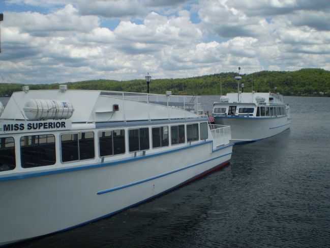
This is the type of boat we were riding in.
View of Munising Bay as we start out - Grand Island on the left, mainland on the right.
That dot in the middle is the boathouse across the street from my house at Sand Point. I could almost see my house from here!
Gulls on a sandbar just past Sand Point.
Miner's Castle in the distance!
The gray rectangle in the upper right is the overlook where I take most of my photos of Miner's Castle from!
Miner's Beach.
Bridal Veil Falls. This is pretty much only visible from a boat. Notice the colors on the cliffs around it - stains as minerals in the rock are dissolved and leached out. Iron makes a rust color, etc. This is why it's called "Pictured Rocks" - the cliffs look as though they had been painted.
Looking back toward Munising - there's some weather happening back there!
The soil is such a thin layer along the edge of the cliffs. Did those trees grow there or did they slide down?
Grand Portal Point. This can be seen from the shore, but that trail is too far for me to hike, so this will be my best glimpse of it!
There were a lot of rock falls - this is sandstone, which is relatively soft and erodes quickly.
A lot of yellow in this section - sulfur?
Indian Head Rock. I saw two faces - one big, one small.
Boats used to be able to go right through this multiple archway, until the ceiling fell in...
Bear Paws!
Blue-green minerals here - definitely some copper in that rock.
Chapel Beach. It's another long hike to this one, but there are some nice stairs down to the beach when you get there! That hike is definitely on my list...
This is Chapel Rock. See that tree on top?
It's hanging on by a thread! This used to be an arch - the rock collapsed, but the roots still reach across. It's a true lifeline - there is nothing to hang onto on the rock itself.
Spray Falls. Another one you can hike to, but it's another long hike! This is where we turned around.
The dark weather had been behind us at the start, but had now caught up - the skies were dark gray, and there was fog building in places on the lake. After we got some rain, the colors in the wet rocks showed up even brighter!
A closer view of Bridal Veil Falls.
Miner's Castle, viewed through a layer of fog.
Hey, there's a raven up there!
Suddenly it was bright and clear, with just a few wisps of fog fading away.
Bright and sunny just as we passed the lighthouse on Grand Island!


No comments:
Post a Comment